Blocks, Plates, and Stones: An Evolutionary History of Cartographic Printing and Design
Date
Time
Location
Cost
How Maps are Made with A.J. Reading
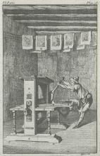
Since the first printed map came into existence in the late 15th century, the relationship between cartographer and printer has been inextricably linked. The dynamics of this essential alliance has been continually shaped over the centuries by the technology and printing methods available at a given time. This talk will explore the many techniques and means of production used in map printing over the past 500 years and how cartographers and printers influenced each other along the way. Additionally, examples of various map types will be shared to illustrate the differences in printing technology and how to identify them.
About the Speaker:
A.J. Reading is the Collections Manager at the MacLean Collection in Lake Forest, Illinois, one of the largest private map libraries in the United States. He studied graphic design and photography at the Minneapolis College of Art + Design, and earned master's degrees in Art history and Arts Administration from the School of the Art Institute of Chicago. A native of the Midwest, A.J. currently lives in Chicago with his wife and two daughters.